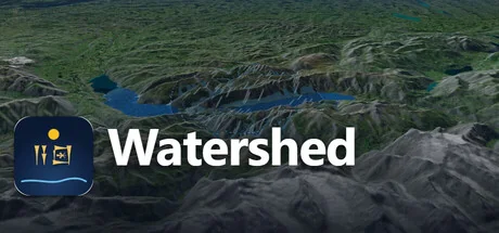
Watershed
Mozon
Rain on real terrain and watch the rivers run. Drain the oceans to the Ice Age and the Persian Gulf becomes a valley. Roll the atlas back to 3000 BC, then send a caravan across what remains. An educational sandbox on real elevation data, with its sources on every layer.
Configuration requise
Exigences minimales
Exigences recommandées
À propos de ce jeu
Weather
Six storm presets with their real order of magnitude, from a desert cloudburst to a monsoon week, or set every number yourself. Turn the rain up until the valley floors become lakes, then ease it off and watch them drain. Cloud shadows, rain and lightning play over readable ground, and a procedural soundscape follows the water.Ocean
Lower or raise the world sea level from 500 m below today to 80 m above, on real bathymetry. The Persian Gulf drains into a river valley, Dover joins Calais, deltas drown.Time
An atlas from 3000 BC to today: cities take their old names, peoples and empires move, roads appear and vanish. Every entry cites its source.Journeys
Place two flags and up to eight stops. A camel or ox caravan walks around the lakes and the sea of the chosen century, fords rivers where it must, stops at wells and cities, and tells you day by day whether the animals would survive.Honest
Every layer is real, public data with its source shown. Every number has a reason. It is a teaching instrument, not an engineering model, and the app says so.For classrooms
Share links reproduce a whole scenario, so a teacher can send a class the exact valley, storm, century and route to explore. Two ready 40-minute lesson plans with worksheets are included.Made by Mozon, a one-person studio in Dubai. Requires an internet connection for map and terrain data.
"Partagez votre expérience de jeu"
Help other gamers! Share how this game runs on your setup, share tips, or ask questions.
Please log in to share your experience with the community!
Jeux les mieux notés
Discover similar games you might enjoy based on genre and creator.


Avis Légal
Les informations sur le jeu, les images, les descriptions et la configuration système requise affichées sur cette page proviennent de plateformes tierces et n'appartiennent pas à Can I Run It. Nous ne sommes ni affiliés, ni approuvés, ni liés aux développeurs, éditeurs ou distributeurs du jeu.
Can I Run It est un service de vérification de compatibilité système qui aide les utilisateurs à déterminer si leur matériel peut exécuter des jeux spécifiques. Nous ne vendons, ne distribuons et n'hébergeons aucun contenu de jeu.
Toutes les marques commerciales, marques déposées, noms de produits et noms de sociétés ou logos mentionnés ici sont la propriété de leurs propriétaires respectifs.
Si vous pensez qu'un contenu affiché viole vos droits de propriété intellectuelle, veuillez nous contacter à [email protected] avec les détails pertinents, et nous répondrons rapidement à vos préoccupations.